Arabian Peninsula’s desert was once home to a vast lake and rivers
New research shows that Arabia’s desert was once home to giant lakes and rivers, reshaped by intense monsoon rains and early human life.
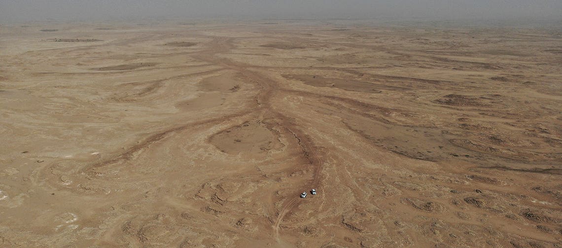
The team led by A. Zaki, S. Castelltort, and colleagues from KAUST studies traces of ancient river and lake systems in Northern Saudi Arabia and the Rub’ al Khali desert. The brown traces represent the beds of ancient streams, organized in dendritic drainage networks that are now abandoned. (CREDIT: Abdallah Zaki)
During the late stages of the last ice age, the Arabian Desert wasn't always the dry expanse you know today. In fact, recent geological and climate research has revealed a very different past—one shaped by powerful monsoons, vast lakes, and flowing rivers.
A new study led by Abdallah Zaki and Sébastien Castelltort of the University of Geneva (UNIGE) reconstructs this forgotten landscape and shows how it reshaped both the environment and patterns of human settlement in the region.
Their work focuses on the Rub’ al Khali Desert, or the Empty Quarter, one of the largest continuous sand deserts in the world. Covering nearly 650,000 square kilometers, the Empty Quarter today is mostly lifeless dunes. But about 11,000 to 5,500 years ago, during a time now called the “Green Arabia” period, this harsh landscape turned lush with lakes, rivers, and greenery.
What caused this dramatic change? Scientists point to the strengthening and expansion of African and Indian monsoon systems that brought sustained and intense rainfall to the region.
Monsoons and Megafloods
During this humid phase, also known as the Holocene Humid Period (HHP), seasonal rains driven by shifting orbital cycles soaked Arabia. The rainfall wasn’t light or infrequent—it was strong enough to reactivate old riverbeds and fill an enormous topographic basin in the Rub’ al Khali. At its peak, one ancient lake covered about 1,100 square kilometers and reached a depth of 42 meters, nearly twice the size of Switzerland’s Lake Geneva.
“The lake is estimated to have been vast, covering an area of 1,100 m² and reaching a depth of 42 meters,” explains Sébastien Castelltort, professor of Earth surface dynamics at UNIGE. As rainfall continued, the lake overflowed, carving out a 150-kilometer-long valley into the desert floor in a massive flood event. This giant waterway didn’t form slowly over thousands of years. It formed rapidly, showing that rainfall in Arabia during this time was far from gentle or gradual.
Using fieldwork, radiocarbon dating, sediment analysis, and remote sensing tools, the team reconstructed this ancient system. They also used Earth system models to simulate past climate conditions. Their results show that intense seasonal rainfall events—possibly fed by monsoons from Africa and India—were strong enough to move sediments over 1,000 kilometers from the Asir Mountains to the low-lying basins of the Empty Quarter.
Related Stories
Zaki, now a postdoctoral fellow at the Jackson School of Geosciences in Texas, adds, “Our work highlights the presence of an ancient lake, which reached its peak around 8,000 years ago, as well as rivers and a large valley shaped by water.”
A Landscape in Flux
The geological features found in the Rub’ al Khali suggest this was no simple story of slow desert greening. Instead, dramatic and repeated changes occurred. While the early to middle Holocene period lasted thousands of years in the south of Arabia, it was much shorter in the north—sometimes only a few hundred years. This uneven distribution of rainfall was likely due to how different atmospheric systems like the African Monsoon, Indian Monsoon, and Mediterranean Westerlies combined or competed in the region.
The sedimentary evidence—such as lacustrine (lake), palustrine (marsh), and fluvial (river) deposits—points to strong and far-reaching water flow systems. These weren’t limited to small-scale runoff. Instead, they moved material and reshaped landforms across vast distances, sometimes up to 1,000 kilometers. This breaks from earlier ideas that increased rainfall simply caused a gentle stabilization of the landscape. Instead, monsoon rains brought floods powerful enough to carve entire valleys.
And it wasn’t just the landscape that changed. These wet periods transformed ecosystems and created grasslands and savannahs across Arabia. Such environments would have supported a variety of plant and animal life and, importantly, made it easier for humans to live and move across the region.
Opening Paths for People
The climate shifts during the HHP did more than reshape the Earth—they reshaped human history. As Arabia became wetter and more hospitable, groups of hunter-gatherers and pastoralists expanded into what is now a barren desert.
Michael Petraglia, professor at Griffith University’s Australian Research Centre for Human Evolution, explains, “The formation of lake and river landscapes, along with grasslands and savannahs, would have facilitated the expansion of hunting, gathering, and pastoral groups into what is now a dry, barren desert. This is confirmed by abundant archaeological evidence found in the Empty Quarter and along its ancient lake and river systems.”
These shifting climates opened migration corridors that helped early humans spread out of Africa and into western Asia. But the favorable conditions didn’t last. Around 6,000 years ago, rainfall declined sharply. The lakes dried, the rivers disappeared, and the green turned to dust.
As arid conditions returned, many groups were forced to leave the area and seek out more livable places. This pattern of climate-driven movement provides insight into how past civilizations adapted to natural shifts—and it serves as a warning in the face of modern climate change.
Lessons for the Future
Understanding how Arabia transformed during the HHP offers more than a glimpse into the past. It also helps scientists improve global climate models. These models are vital for predicting how current and future monsoon shifts may affect vast dry regions like the Sahara and Arabian deserts.
To simulate the greening of the Saharo-Arabian belt accurately, researchers need to understand not just when rainfall occurred, but how much rain fell, how intense it was, and how it reshaped the land. The Rub’ al Khali landscape is a key testing ground for these models.
The study’s integrated approach—combining sediment data, climate modeling, and isotope analysis—offers a detailed and reliable picture of how the Arabian Desert responded to monsoon activity. It helps answer long-standing questions about the role of African and Indian monsoons in shaping the environment and guiding the movement of ancient peoples.
This scientific story, uncovered in rocks and dry riverbeds, tells of a world that once flourished with water and life. It’s a reminder that even the most desolate places today may hold secrets of vibrant pasts—and important clues for our future.
Research findings are available online in the journal Communications Earth & Environment.
Note: The article above provided above by The Brighter Side of News.
Like these kind of feel good stories? Get The Brighter Side of News' newsletter.