Hidden ocean currents play a crucial role in global weather, study finds
New satellite maps reveal how small ocean currents drive climate, weather, and marine life across the globe.
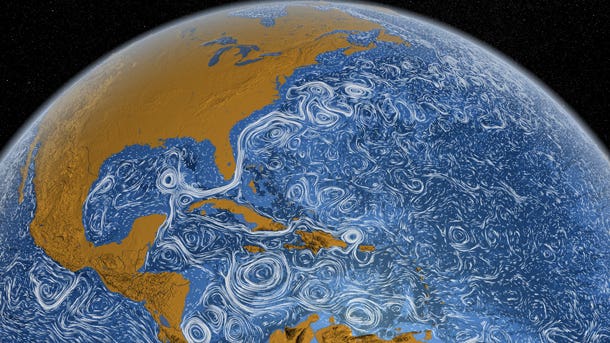
A Texas A&M-led study using a $1B satellite mission reveals how tiny ocean eddies and waves play a massive role in Earth’s climate system. (CREDIT: NASA Goddard Photo and Video, Flickr, CC BY 2.0)
For centuries, scientists have known that oceans move and swirl, shifting water across the planet. But recent breakthroughs are revealing that some of the smallest currents are surprisingly powerful drivers of Earth’s climate. A team led by researchers at Texas A&M University has now mapped these elusive ocean flows in remarkable detail, thanks to a revolutionary satellite mission two decades in the making.
Unlocking the Mystery of Submesoscale Eddies
You might think only massive ocean currents like the Gulf Stream affect global weather. But swirling mini-currents, known as submesoscale eddies, play a crucial hidden role. These underwater spirals range from 1 to 100 kilometers wide. Until now, they were too small and fast-changing to be seen from space.
"They were the missing piece," said Jinbo Wang, an associate professor at Texas A&M’s Department of Oceanography. Before joining the university, Wang spent nine years at NASA’s Jet Propulsion Laboratory, where he helped design the tools to uncover these currents.
These eddies behave like small whirlpools in a river. They swirl around, mixing warm and cold water, and move nutrients, heat, and energy through the ocean. They also influence hurricanes, El Niño, and other weather events. Their effects ripple far beyond the sea.
Until recently, satellites could only detect ocean features larger than 100 kilometers. This meant most of the fine-grained movement was invisible, even though it helps mix heat and regulate Earth’s climate.
A Satellite Mission 20 Years in the Making
To finally see these mini-currents, NASA and France's CNES space agency teamed up with other partners to create the SWOT mission: Surface Water and Ocean Topography. Launched in 2022, this $1 billion satellite carries a breakthrough instrument called the Ka-band Radar Interferometer (KaRIn).
Related Stories
KaRIn scans a 120-kilometer-wide strip of ocean, mapping sea surface height with millimeter-level accuracy. The result? Clear views of ocean activity, including the never-before-measured submesoscale eddies and internal waves.
“The satellite performed four times better than expected,” Wang said. “That surprise is what made this breakthrough possible.”
The radar not only spotted eddies, but also internal solitary waves — long, deep waves that travel beneath the ocean surface. These waves were previously seen in radar images from planes or space, but their energy and size were never measured at this level before.
Early results blew past expectations. In a single snapshot over the Indian Ocean's Mascarene Plateau, SWOT revealed eddies, wave packets, and even ocean swells just hundreds of meters long. Scientists didn’t even expect to see those.
Why These Currents Matter
Submesoscale eddies may be small, but they pack a punch. They transport energy across the ocean and stir nutrients from deep below. This vertical mixing supports marine life like phytoplankton, the base of the food web. More mixing means healthier oceans.
They also help regulate the flow of gases such as oxygen and carbon dioxide between the ocean and the air. These exchanges affect climate and weather systems around the world.
"Just like tiny airways in your lungs allow oxygen to enter your blood, these currents act like ducts that move heat and gases into the deep ocean," explained Wang.
For example, internal waves created by tides bouncing off underwater mountains travel long distances, pushing energy across entire ocean basins. Until SWOT, scientists had little data to measure how much energy they carried.
Now, with the satellite’s ultra-precise imaging, scientists can track how fast these features move and how much energy they carry. This helps improve climate models, which guide forecasts for everything from hurricanes to global warming.
In some cases, regions rich in kinetic energy, such as the Gulf Stream or the Kuroshio current, showed dramatic differences between old and new satellite data. SWOT’s readings captured powerful activity that traditional satellites missed entirely.
A New Era in Ocean Science
Texas A&M has made long-term investments in ocean research, and hiring Wang was part of that strategy. His background in both satellite engineering and ocean physics made him an ideal leader for this effort.
"This is a tribute to teamwork and vision," said Dr. Shari Yvon-Lewis, head of Texas A&M’s Oceanography Department. "Many of the people who started this mission have since retired."
Wang also leads NASA’s Ocean AI working group, where scientists explore how artificial intelligence can help analyze massive satellite datasets. That technology could speed up discoveries and guide the design of future satellites.
But even with cutting-edge tools, this is just the beginning. SWOT has shown that the global ocean is full of activity that no one could see before. Its data gives researchers the first global look at ocean turbulence smaller than 100 kilometers. That’s a game-changer.
In places like the Amazon River mouth and the South China Sea, the satellite revealed swirls and waves never documented. These features can change quickly, so the satellite’s fast imaging helps researchers spot them in real time.
The satellite’s success also challenges previous ocean models. Scientists now see that many past predictions may have overlooked important small-scale dynamics. This has major implications for how we understand long-term climate patterns.
From Space to Climate Solutions
Now that these submesoscale features can be seen and measured, scientists can adjust global models for better accuracy. Predicting how oceans move and mix is key to tracking carbon, heat, and storm behavior.
Mesoscale eddies — the larger cousins of submesoscales — carry more than 80% of the ocean's kinetic energy. But the smaller features help move that energy downward, where it can be absorbed and eventually dissipated.
This process balances the ocean's energy and helps regulate Earth’s climate engine. Without the ability to measure these currents, climate models were missing part of the picture.
With SWOT, researchers now have data down to scales of just one kilometer. That’s a thousand times more detailed than what was available a few decades ago. More detail means better predictions.
This global mapping comes at a time when ocean conditions are changing rapidly. Sea surface temperatures are rising. Currents are shifting. Ice sheets are melting. And major systems like El Niño are becoming more frequent and intense.
Understanding these patterns is critical. With better data, scientists can now ask — and answer — new questions. How do internal waves affect fish migration? Can eddies trigger rapid changes in sea surface temperatures? How might they influence coastal storms?
For Wang and his team, having their work featured on the cover of Nature was a milestone — but not a final destination. "This is just the beginning," he said. "We finally have the tools to see what’s been hiding in plain sight."
This insight helps close the gap between what satellites could show and what the ocean was really doing. Thanks to the teamwork of engineers, scientists, and space agencies around the world, one of Earth’s most powerful climate tools — the ocean — is becoming easier to understand.
Note: The article above provided above by The Brighter Side of News.
Like these kind of feel good stories? Get The Brighter Side of News' newsletter.