Karnak’s hidden island: What lies beneath Egypt’s great temple
Study reveals Karnak Temple was built on a natural island shaped by Nile channels, linking geology and Egyptian mythology.
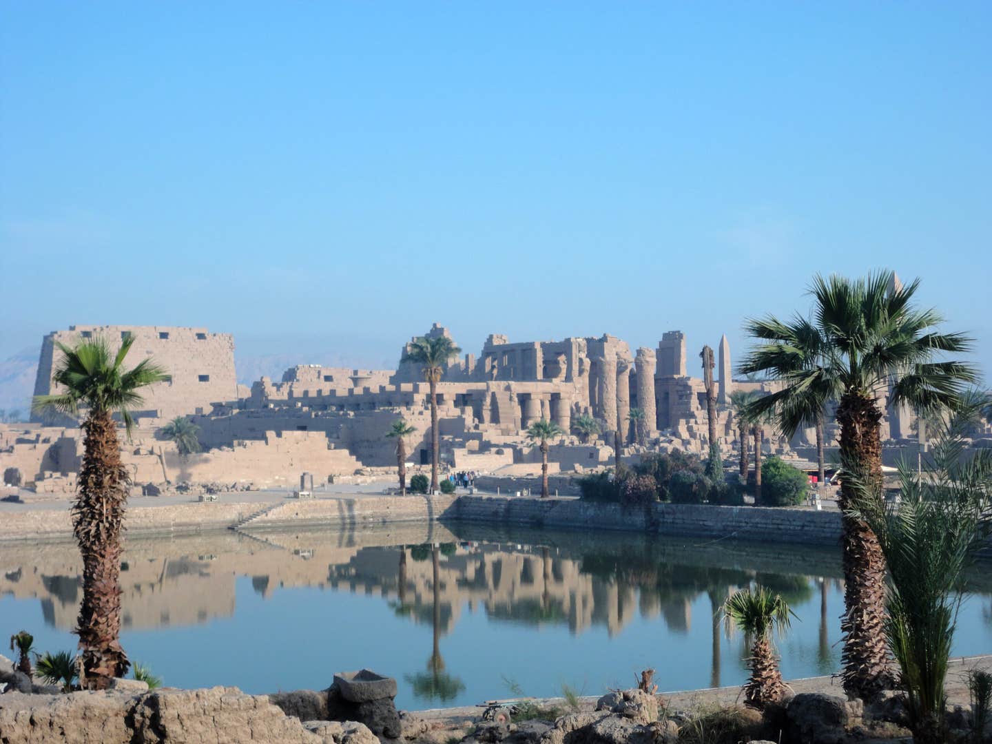
Ancient ruins of the Karnak Temple complex in Luxor, Egypt. (CREDIT: Dr Ben Pennington)
Five hundred meters east of today's Nile, in the city of ancient Thebes, rises one of Egypt's greatest and most enduring monuments: the temple complex of Karnak. Over 3,000 years, its colossal pylons and extensive courtyards dedicated gods Amun-Ra, Montu, and Mut.
But despite all the millennia of pilgrimages and excavations at Karnak, one secret was buried under the stone—the history of the land itself. How did the Nile and the shifting banks shape this sacred site?
New research gives the most comprehensive reconstruction so far of how the ground under Karnak was assembled and transformed. The findings reveal that the temple was not built on flat ground at all, but on a prehistoric river channel-crafted natural island terrace—a choice that may have had profound spiritual meaning.
Digging Beneath the Stones
An interdisciplinary research team, led by Uppsala University's Dr. Angus Graham and his colleagues at the University of Southampton, teamed geology, archaeology, and cutting-edge dating to trace the deep past of the temple. They cored 61 sediment cores on the site, some 11 meters below ground level. Each sand and silt layer contained a narrative about the history of the Nile.
Tens of thousands of ceramic shards helped the scientists determine the ages of those buried layers. "The age of Karnak Temple has long been controversial among archaeologists," said Dr. Kristian Strutt, a co-author at Southampton. "Our new evidence places a firm temporal limit on its earliest occupation and construction.".
To further constrain the timeline, the researchers used optically stimulated luminescence dating—a method that digs up when sand grains were last exposed to the light. Together, the sediment cores, ceramics, and OSL data formed a 3D picture of how the terrain beneath Karnak changed over the millennia.
A Temple on an Ancient Terrace
At the temple's foundation, researchers discovered a thick accumulation of river-borne sands overlain by silt and wind-blown deposits. The oldest of these sandy units, Unit T, contained very little evidence of human presence—i.e., deposited before the first settlers arrived.
One OSL date put the final Unit T deposition at approximately 2520 BCE, give or take four centuries. So, the site would have still been a functioning river channel by then—too unstable for permanent construction. "Prior to about 2520 BCE, the site would have been unsuitable for occupation due to recurrent inundation by high-velocity Nile water," explained Dr. Ben Pennington, lead author and Visiting Fellow in Geoarchaeology at the University of Southampton.
It was only much later, when the channels of the river deepened and trended back and forth, that Karnak's sands emerged above water to form an island of high ground. This natural ledge, about 10 hectares in size, was the basis for one of humankind's greatest temples.
The Nile's Ever-Changing Paths
Researchers discovered that two major river channels had formerly surrounded this high island. To the west, an earlier Middle Kingdom channel progressively clogged up and deposited land for temple expansion. In the New Kingdom, builders even closed the old channel with desert sand to stabilise ground for new buildings. One central south of the Hypostyle Hall contained a 3.6-meter-thick fill of foreign sand—proof of deliberate landscape engineering by ancient builders.
To the east, researchers identified another, much longer extension of the Nile hitherto undervalued. The eastern channel may once have extended nearly half a kilometer in width, a large watercourse during First Intermediate and Middle Kingdoms. It also migrated over centuries and finally silted in, riverbed and then floodplain by late antiquity.
"The river channels that border the site dictated where and how the temple would expand," added Southampton researcher Dominic Barker. "We can also observe how Ancient Egyptians altered the river itself, infilling channels with desert sands, maybe in order to create new land upon which to build."
A Sacred Island in a Sea of Myths
Apart from its geology, the research provides insight into how religion and landscape met at Karnak. The position of the temple on a high mound surrounded by water may have symbolized one of Egypt's first creation myths. During the Old Kingdom, sacred texts refer to the creator god rising as a mound out of the chaotic waters of the primordial flood.
It is tempting to suppose the Theban aristocracy chose the site of Karnak to be the home of a new incarnation of creator god Ra-Amun, since it was in conformity with that cosmogonic vision of high arising out of water around it," Pennington stated.
Every year, when the Nile flowed in and receded, the temple terrace would seem to rise out of the floodwaters—mirroring the mythological "primeval mound" from chaos. Land, water, and the divine could not possibly have been linked by chance at all.
From River Island to Religious Powerhouse
With the passage of centuries, the temple spread outward. Architects discovered ways to adapt to the constantly changing landscape, filling channels, deflecting flows, and overspreading ancient riverbeds as they consolidated. The simple shrine on an islet increased to a huge religious metropolis, spanning approximately 30 hectares in its central precinct of Amun-Ra.
Each stage of construction was as much an architectural ideal as an environmental one. When the western channels became clogged with sediment, new land reappeared—perfect for expansion. When floods threatened the sanctuaries, workers re-engineered the landscape. As the centuries passed, the relationship between humans and the Nile turned the temple complex into both a geological and cultural icon.
The Karnak Temple's history, from a small island to one of the typical institutions of Ancient Egypt, is that of the harmony between humanity and nature," Pennington said.
Practical Applications of the Study
This study alters what archaeologists know about ancient Egyptian cities—not as static ruins, but as constantly evolving landscapes sculpted by time, sediment, and water. An understanding of how the Nile's changing channels impacted settlements may help preserve sites under threat from modern river avulsions or increasing groundwater.
The discoveries also provide insight into how ancient cultures perceived the surroundings of their world—not as a setting, but as an active participant in religion and existence. For today's scientists, this research opens the door between geology and archaeology, providing new means of tracking how human history developed alongside the natural elements.
As Pennington's team expands its survey to the entire Luxor floodplain, it will aim to map how rivers and temples interlocked within Thebes, telling us more about one of the world's most ancient cultural landscapes.
Research findings are available online in the journal Antiquity: Cambridge University Press.
Related Stories
- Archeologists reveal how ancient Egyptians built the pyramids
- 2,500-year-old lost city of Thonis-Heracleion discovered in Egypt
- Bust of Cleopatra VII may have been found at ancient Egyptian temple
Like these kind of feel good stories? Get The Brighter Side of News' newsletter.
Joseph Shavit
Writer, Editor-At-Large and Publisher
Joseph Shavit, based in Los Angeles, is a seasoned science journalist, editor and co-founder of The Brighter Side of News, where he transforms complex discoveries into clear, engaging stories for general readers. With vast experience at major media groups like Times Mirror and Tribune, he writes with both authority and curiosity. His writing focuses on space science, planetary science, quantum mechanics, geology. Known for linking breakthroughs to real-world markets, he highlights how research transitions into products and industries that shape daily life.