Mysterious 4,000-Year-Old ‘Treasure Map’ Unlocks Secrets From Our Ancient World
In archaeology, few discoveries capture the imagination quite like the unearthing of ancient maps. They are time capsules into the past
[Oct. 19, 2023: Staff Writer, The Brighter Side of News]
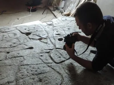
The slab is shown here being photographed by a scientistY. Pailler, Inrap, Examining the Saint-Bélec slab
In archaeology, few discoveries capture the imagination quite like the unearthing of ancient maps. They are time capsules, offering a glimpse into the minds and worlds of civilizations long gone. Such is the case with the Saint-Belec Slab, a mysterious artifact that, after lying dormant and unstudied for over 4,000 years, has sparked a revolutionary archaeological endeavor in northwestern France.
Discovered within an ancient tomb, this enigmatic stone slab is capturing global attention, not merely as a relic but as a pivotal archaeological key. Researchers in 2021 acclaimed it as Europe's most ancient known map, a claim that catapulted the Saint-Belec Slab from obscurity to the focal point of an intricate historical puzzle spanning centuries and civilizations.
"The implications of the Saint-Belec Slab for our understanding of Bronze Age Europe are profound," explained Yvan Pailler, a professor at the University of Western Brittany (UBO). "It's not just a map; it's a window into the past, a narrative etched in stone, awaiting decryption."
The slab, heralded by Pailler as a "treasure map," presents a unique opportunity for archaeologists. Traditional methods of discovering ancient sites—like sophisticated radar scans, aerial photography, or happenstance finds during urban excavations—recede in the face of this tangible, millennia-old guide to the lost monuments of ancient France.
Related Stories
However, the path to revelation is an extensive, painstaking endeavor. According to Clement Nicolas of the CNRS research institute, surveying the territory indicated by the map—a sprawling 30 by 21 kilometers—and correlating it with the slab's inscriptions is a colossal task that could span 15 years or more.
The journey of the Saint-Belec Slab to contemporary relevance is a tale steeped in historical serendipity. Initially unearthed in 1900 by a local historian, the artifact's true significance lay unrecognized. It wasn't until 2014 that a team, including Nicolas and Pailler, re-discovered the slab, prompting a re-evaluation of its engravings and their historical implications.
Over a century ago, the slab's extraction from its primordial resting place required over a dozen workers, underscoring its monumental nature. According to the National Archaeology Museum, where the relic has resided since 1924, it was retrieved from a burial chest's wall within a mound. Accompanying the slab was a broken ceramic vessel, a telltale sign of early Bronze Age society, as reported by the French Prehistoric Society.
A Bronze Age map discovered in 1900 in Saint-Bélec finally deciphered? A “treasure map” according to archaeologist Yvan Pailler. (CREDIT: UBO_UnivBrest)
Deciphering the slab's markings is an international effort, pooling expertise from various institutions within France and abroad. "There were a few engraved symbols that made sense right away," Pailler recalled, alluding to the immediate recognition of certain topographical representations amidst the slab's coarse etchings.
Indeed, the etched contours on the stone slab mirrored the geographical features of Roudouallec, in the Brittany region, approximately 500 kilometers west of Paris. By scanning the slab and juxtaposing its details with contemporary maps, the researchers discerned an approximate 80% correspondence.
High definition 3D-scanning of the Saint-Bélec carved slab with ATOS Compact Scan. (CREDIT: V. Lacombe)
Nicolas, delving into the specifics of the etchings, noted, "We still have to identify all the geometric symbols, the legend that goes with them." The slab is replete with diminutive hollows, speculated to signify anything from burial mounds and habitations to geological formations. Unveiling their significance could instigate a deluge of archaeological discoveries across the region.
The immediate focus, however, remains on the original discovery site. Described by Pailler as "one of the biggest Bronze Age burial sites in Brittany," the location has become a nexus of archaeological activity, with experts striving to unearth further context and a more precise chronology for the slab.
Photograph of the carved slab from Saint-Bélec, Leuhan, Finistère, in the early XXth century (CREDIT: P. du Chatellier, Archives départementales du Finistère, Quimper)
This endeavor has already borne fruit, revealing additional fragments of the slab, previously undiscovered. These remnants, seemingly detached and repurposed as tomb wall components, might epitomize the turbulent power shifts of Bronze Age communities.
Nicolas hypothesizes that the territory depicted on the map could correspond to a once-mighty kingdom, potentially toppled by internal strife and rebellion. "The engraved slab no longer made sense and was doomed by being broken up and used as building material," he reflected, contemplating the possible decline of a forgotten realm.
The barrow of Saint-Bélec 1, Leuhan, Finistère. 1: viewshed analysis from the barrow; 2: detail of the local topography; 3 : aerial photograph of the two barrows of SaintBélec; 4: view from the south of the two barrows of Saint-Bélec with the elevated montagnes Noires in the background. (CREDIT: C. Nicolas)
The Saint-Belec Slab, thus, transcends its material form. It is a narrative, a testament to the dynamic histories and cultural complexities of ancient societies. As researchers continue to decode its symbols, the slab promises not only a flurry of new archaeological sites but also profound insights into the human past.
For archaeologists and historians alike, the slab challenges established conventions, encouraging a reimagining of ancient societal structures, the interplay of power, and the very fabric of Bronze Age life in what is now modern France.
The treasure map, as Pailler aptly dubs it, is charting a course not just across the physical landscapes of ancient France but through the temporal layers of human civilization itself. And as each marking is decoded, the Saint-Belec Slab stands as a silent sentinel, offering cryptic directions in a quest that weaves through the annals of time, unearthing stories long buried and kingdoms long lost to the ages.
For more science stories check out our New Discoveries section at The Brighter Side of News.
Note: Materials provided above by the The Brighter Side of News. Content may be edited for style and length.
Like these kind of feel good stories? Get the Brighter Side of News' newsletter.