New ESA satellite launches to weigh the world’s forests from space
A new European satellite is weighing the world’s forests from space, giving scientists precise data to sharpen climate models and guide policy.
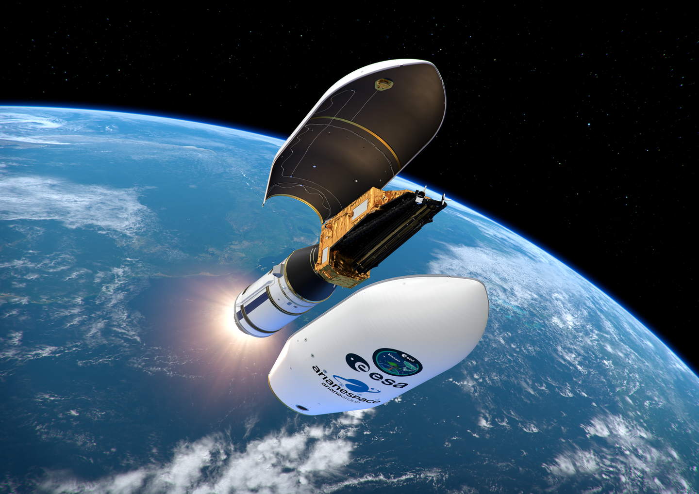
The Biomass satellite is weighing the world’s forests from space, offering vital new data to improve climate models and policy. (CREDIT: ESA)
On April 29, a rocket lifted off from Europe’s Spaceport in Kourou, French Guiana. Aboard it was a satellite designed to answer one of the most important questions in climate science: how much carbon do Earth’s forests hold? Known as Biomass, this European Space Agency (ESA) mission carries technology capable of weighing the planet’s forests from orbit. The work leading to this breakthrough includes key contributions from researchers at Chalmers University of Technology in Sweden.
For decades, scientists have known that forests play a central role in regulating the climate. Trees act like enormous sponges, pulling carbon dioxide from the air and storing it in trunks, branches, roots, and soil. Yet until now, the true amount of forest carbon has remained uncertain.
Even though forests cover nearly one-third of Earth’s land, measurements have often been limited to small areas and rough estimates. Without global-scale data, researchers have struggled to fully understand how forests fit into the broader carbon cycle.
Weighing the world’s forests from space
The launch of Biomass marks a turning point in climate research. Using advanced radar, the satellite will map forests worldwide with a detail never before achieved. Instead of only scanning the canopy—the leafy upper layer of trees—the satellite’s radar penetrates deep enough to reveal the entire structure, from crown to ground. That ability is the key to calculating how much living material is present.
The radar operates at a wavelength of 70 centimeters, far longer than those used in earlier missions. This allows it to see through leaves and branches that typically block shorter signals. By collecting this data over time, Biomass will create a three-dimensional picture of forests on every continent. Scientists will not only see how much carbon is stored but also track how these stocks shift with logging, wildfires, storms, or climate-driven die-offs.
Orbiting 666 kilometers above Earth, the satellite will circle the planet every 93 minutes. Over the course of several months, it will generate complete maps of global forests, then repeat the process. This cycle ensures that researchers can follow trends, measure losses, and spot gains as forests recover or expand.
Related Stories
- From bread to Mars: The promise of yeast in space
- NASA veteran unveils propellant-free space drive that could redefine exploration
A twenty-year scientific journey
The roots of this mission stretch back two decades. Almost 20 years ago, Lars Ulander, a professor of radar remote sensing at Chalmers University of Technology, and his colleagues submitted a bold proposal to ESA. Their vision was a radar satellite dedicated to measuring forest biomass on a planetary scale. “Our idea was to use a very special type of radar to map the world’s forests from space. The goal was to understand how forests affect the climate – and how climate change affects forests,” explains Ulander.
At the time, the concept faced technical hurdles. Designing instruments sensitive enough to detect forest mass from orbit required years of engineering. The radar had to be strong enough to send signals deep into dense woodlands but precise enough to avoid distortion.
After years of testing and development, the mission finally became reality. Now, the Biomass satellite is ready to deliver on that early vision. It represents not just a scientific leap but also a triumph of persistence, patience, and international collaboration.
Why forest biomass matters for the carbon cycle
Forests hold about 80 percent of all the carbon stored in vegetation. This makes them one of the largest buffers against rising greenhouse gases. When forests grow, they absorb carbon dioxide. When they burn or are cut down, that stored carbon returns to the atmosphere, fueling climate change.
Until now, estimates of global forest biomass have been pieced together using scattered ground surveys, aerial photos, and satellite images that only captured surface features. These approaches left large uncertainties, especially in tropical regions like the Amazon and Congo basins where dense canopies hide much of the structure below.
Accurate measurements from Biomass will reduce these uncertainties and refine global carbon budgets. With better numbers, climate models can predict future warming more reliably. This will also help governments design stronger policies for forest protection and restoration.
Climate models gain sharper focus
One of the mission’s main goals is to sharpen the accuracy of climate projections. Current models depend on assumptions about how much carbon forests absorb or release. Small errors can add up, leading to significant uncertainty in predictions of global warming.
By supplying direct data, Biomass will anchor these models in real measurements. Scientists will be able to assess, for instance, how drought in the Amazon reduces carbon storage, or how boreal forests in Siberia respond to rising temperatures. This feedback between forests and climate has long been a blind spot. Filling it in could reshape how policymakers plan for the decades ahead.
A tool for decision-makers
The satellite’s maps will be freely available to researchers and governments around the world. This open access means nations can monitor their own forest resources with greater accuracy. It also allows international organizations to track whether conservation promises are being met.
With global deforestation still responsible for about 10 percent of greenhouse gas emissions, knowing exactly where and how much forest is lost each year is vital. More precise monitoring can strengthen programs that reward countries for protecting forests, such as the United Nations’ REDD+ initiative. The data may also support reforestation projects by showing which regions are storing the most carbon after trees are planted. As nations strive to meet their climate targets, these insights could prove invaluable.
Looking ahead
Biomass is planned to operate for at least five years, though many ESA satellites often exceed their expected lifespans. During that time, it will collect a vast archive of information about Earth’s living carbon reserves. Scientists hope the mission will become a cornerstone for future climate studies.
For Ulander and his team, the launch is both the end of a long journey and the beginning of a new era of discovery. What began as an ambitious proposal on paper has now become a tool orbiting hundreds of kilometers above the Earth, silently weighing the forests that help sustain life.
As the data flows in, the world will gain a clearer picture of how forests breathe, grow, and change. With that knowledge comes power—the power to make smarter choices in the fight against climate change.
Research findings are available on the ESA website.
Note: The article above provided above by The Brighter Side of News.
Like these kind of feel good stories? Get The Brighter Side of News' newsletter.