New study reveals the links between climate, earthquakes and human evolution
Shrinking Lake Turkana eased pressure on the crust, speeding faults and magma, tying climate change to earthquakes and rifting.

 Edited By: Joshua Shavit
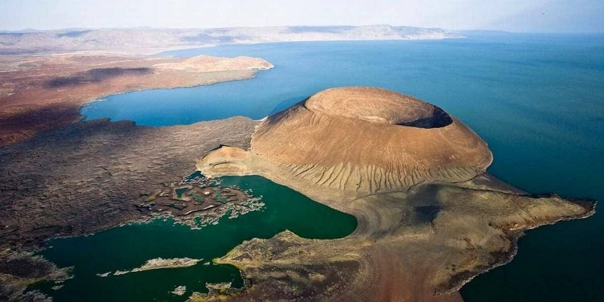
In northern Kenya, the quiet surface of Lake Turkana hides a deeper story. (CREDIT: Wikimedia / CC BY-SA 4.0)
Along the dry shores of northern Kenya, a long turquoise lake quietly records the tug of deep forces. Lake Turkana looks peaceful from the surface. Yet as its waters have risen and fallen with changing climate, the ground beneath it has stretched, cracked and even welcomed new magma from below.
A new study of this desert lake shows that climate does more than change rainfall and heat. It can loosen the grip on the Earth’s crust, speed up movement on faults and encourage magma to rise. In the East African Rift, where a continent is slowly tearing apart, the air above and the rock below are more connected than you might expect.
A rift lake in a restless landscape
The East African Rift is one of the few places where you can watch a continent split in real time. Long valleys cut through the land from Ethiopia toward Mozambique. Some hold giant lakes. Others hold chains of volcanoes.
Lake Turkana sits in the Turkana Depression, in the eastern branch of the rift. The lake stretches about 250 kilometers from north to south and reaches 30 kilometers wide. On average it is about 30 meters deep, with the deepest spots near 120 meters. It is also the world’s largest permanent desert lake and lies in a region often called the cradle of humankind because of its rich fossil record.
Around 2.2 to 2.0 million years ago, volcanic eruptions blocked an ancient river outlet and created a closed basin. That early lake, once called Lake Lorenyang, later became Lake Turkana. Since then, shifting climate has swung the lake between high and low stands by hundreds of meters.
During a humid phase about 9,600 to 5,300 years ago, sometimes called the late African Humid Period, the lake stood much higher than today. Then the climate dried. Between about 6,000 and 4,000 years ago, the water level dropped roughly 100 to 150 meters and entered the low phase that continues now.
How water weight changes the crust
A deep lake presses hard on the crust beneath it. When water levels fall, that weight lightens. You can think of it as taking a heavy pack off your shoulders; your spine uncoils and shifts. The crust reacts in a similar way when a giant water load comes off.
James Muirhead, a senior lecturer at the University of Auckland, and colleagues wanted to see whether that long drop in lake level left a mark on the faults under Turkana. “We tend to think of earthquakes and volcanoes as being driven purely by deep forces inside the Earth,” Muirhead says. “But what we’re seeing here is that surface processes – like climate and rainfall – also play a role.”
The team focused on the South Turkana Basin, a roughly 30 kilometer wide zone of faults and magmatism centered on South Island volcano. Earlier work had used more than 1,100 kilometers of high resolution seismic reflection profiles under the lake, paired with radiocarbon dated sediment cores. Those data showed that this part of the rift stretches at about 3.5 to 5.8 millimeters per year, with most strain close to the axial volcano.
For the new study, the group picked out two main layers in the lakebed sediments. One was deposited during the wetter, high lake period between 9,631 and 5,333 years before present. The younger layer formed after 5,333 years before present, once the water had already fallen more than 100 meters. That timing turned the basin into a natural before and after experiment.
Reading hidden motion from buried faults
To track how fault motion changed, the researchers measured the vertical offset, or “throw,” on those two sediment layers wherever they crossed a fault. They focused on 27 of the largest faults where offsets could be clearly seen on both horizons. Using the age of each layer and the amount of offset, they calculated average slip rates for each period.
Both the ages and the throw values carry some uncertainty, so the team used a Monte Carlo approach to explore the full range of possible histories. For each fault they ran 1,000 simulations that allowed the layer ages and seismic velocities to vary within realistic limits. For every simulated history, they computed an average throw rate during the humid period and another for the drier period up to 2010, when the seismic data were collected.
Across all 27 faults, the change in throw rate from the wet phase to the dry phase ranged from a slight drop of 0.15 millimeters per year to a rise of 1.16 millimeters per year. On average, the population showed an increase of 0.17 ± 0.08 millimeters per year at 90% confidence. About 74% of the faults sped up in a statistically significant way. Only 11% showed a clear slowdown.
The strongest boosts appeared along the western border faults and near the magmatic axis tied to South Island volcano. That pattern hinted that falling lake levels were not working alone. Magma rising from depth likely helped tip many faults closer to failure.
Magma pressure joins the story
To test how water and magma each affected stress in the crust, the team used a 3D numerical model called PyLith. In one set of runs, they treated lake level as a changing surface load using a reconstructed curve of water depth over the past several thousand years. In another, they added a spherical magma chamber about 3 kilometers in radius, centered 10 kilometers below South Island, in line with fluid inclusion measurements from local volcanic rocks.
As the climate dried and the lake dropped 100 to 150 meters, the crust beneath lost a huge water load. That unloading also lowered pressure deeper down, which encouraged decompression melting in the hot mantle. Earlier numerical work suggested that such unloading could boost melt production by about 0.07 to 0.34 cubic kilometers per thousand years in a 50 kilometer long basin. For Turkana, the team used an extra melt flux of 0.154 cubic kilometers per thousand years feeding the South Island magma chamber over the last 5,000 years.
Lake unloading alone produced Coulomb stress changes of about 95 to 230 kilopascals on modeled normal faults in the basin. Inflation of the magma chamber, fed by that extra melt, produced increases as high as 650 kilopascals. Both effects pushed faults closer to failure and favored normal faulting during the low lake phase. Yet the magma pressure clearly dominated in this setting.
The idea fits what scientists see in other magmatic rifts, such as Afar, Iceland and Hawaii. As magma chambers overpressurize, they can feed sheetlike intrusions called dikes into the brittle crust. Those dikes split the crust and encourage nearby normal faults to slip. Even modest stress changes from rainfall can trigger such diking in some regions. At Turkana, the combined stress from lake unloading and magma inflation is even larger, making faults especially sensitive to climate driven changes.
Climate, sediment and early humans
Climate does not only affect water. It also controls how much sediment rivers deliver into rift basins. Cores from Lake Turkana show sedimentation rates between 0.6 and 2.4 millimeters per year through the Holocene, with about a 60% drop after the humid period. If you assume a mean reduction of 1.5 millimeters per year since 5,333 years before present, the missing sediment adds up to around 7.9 meters in thickness. That sounds like a lot, but the lost water load from a 100 to 150 meter lake level drop is roughly ten times larger. On thousand year time scales, lake unloading dwarfs sediment changes as a driver of stress.
For early hominids and later humans, these slow but powerful shifts would have shaped the landscapes they called home. During drier phases, they may have faced more frequent earthquakes and volcanic activity as faults sped up and magma production rose. That would have influenced where water collected, where fertile soils formed and which routes remained safe to travel.
Lake Turkana today still presents challenges. “The lake is the largest in the world in a desert, is in one of the windiest places in Africa and is extremely remote,” says Syracuse University professor Chris Scholz. He notes that fieldwork there required hauling research vessels overland and operating without any coast guard support. Yet those efforts produced detailed scans of 27 faults that Muirhead describes as “arguably the best estimates on fault activity rates over the past 10,000 years of any rift basin in the East African Rift System.”
Practical Implications of the Research
This work shifts how you can think about plate tectonics. “Continental break-up is generally thought of as a process fundamentally rooted in plate tectonics,” Scholz says. “Our research shows that rifting is also shaped by surface processes, including regional climate.” That Earth systems view matters for both scientists and communities living in active rifts.
For hazard planners, the message is clear. Fault behavior in continental rifts may depend on climate state and water storage. Muirhead puts it plainly: “If I were doing a hazard assessment for a fault line in a continental rift like Turkana, I would need to consider how its rate of activity, and resulting likelihood of an earthquake, is affected by the current climate state and associated lake water volumes.” That kind of thinking could eventually refine seismic risk maps in regions where lakes, glaciers or large reservoirs change through time.
The research also carries a quiet warning about long term climate change. “Climate change, whether human-induced or not, will likely impact the probability of future volcanic and tectonic activity in East Africa,” Muirhead says. These effects unfold over geological spans, so you would not notice them in a single lifetime. Even so, they remind you that actions in the atmosphere can feed back into the solid Earth on longer horizons.
Future work may apply similar methods to other rift lakes or to regions that recently lost large ice sheets. By linking lake levels, magma supply and fault slip, scientists gain a fuller picture of how Earth’s systems talk to one another. In the long run, that knowledge can guide safer development in rift zones, protect water and energy resources and deepen your understanding of how a changing climate shapes the ground beneath your feet.
Research findings are available online in the journal Scientific Reports.
Related Stories
- San Andreas fault earthquakes may be significantly larger in the future
- Satellite data reveals climate change is lifting South Africa out of the ocean
- Effects of climate change are shifting the Earth’s axis, study finds
Like these kind of feel good stories? Get The Brighter Side of News' newsletter.
Mac Oliveau
Writer
Mac Oliveau is a Los Angeles–based science and technology journalist for The Brighter Side of News, an online publication focused on uplifting, transformative stories from around the globe. Passionate about spotlighting groundbreaking discoveries and innovations, Mac covers a broad spectrum of topics including medical breakthroughs, health and green tech. With a talent for making complex science clear and compelling, they connect readers to the advancements shaping a brighter, more hopeful future.