Revolutionary mobile app assists blind and visually impaired commuters
Innovative micro-navigation smartphone app promises to transform the lives of individuals who are blind or visually impaired
Innovative micro-navigation smartphone app that promises to transform the lives of individuals who are blind or visually impaired. (CREDIT: TVST)
In a significant breakthrough, a team of researchers at Mass Eye and Ear has developed an innovative micro-navigation smartphone app that promises to transform the lives of individuals who are blind or visually impaired (BVI).
The newly released study reveals that this cutting-edge app, named "All_Aboard," outperforms Google Maps in helping BVI individuals navigate their way to bus stops with astonishing success rates.
While existing GPS systems excel at macro-navigation, such as planning routes using public transportation, micro-navigation, which involves pinpointing the precise locations of bus stops and destinations, has remained a daunting challenge for those with visual impairments.
The accuracy of GPS-based localization for micro-navigation has often been lacking. In response to this issue, the team at Mass Eye and Ear developed the All_Aboard app, designed to complement mainstream GPS systems by enhancing micro-navigation capabilities.
Related Stories
All_Aboard is a game-changer in the world of navigation for the visually impaired. When a GPS signals that a BVI user is nearing their intended destination, the All_Aboard app is activated. The app utilizes the smartphone's camera to detect street signs from a distance of 30 to 50 feet.
Once a sign is identified, the app employs auditory cues to guide the user towards their final destination. These cues change in frequency as the user approaches the bus stop.
What makes All_Aboard even more remarkable is its use of artificial intelligence, powered by a deep learning neural network. This network has been meticulously trained on a database containing around 10,000 images of bus stops from various cities and regions. As a result, All_Aboard is currently proficient at recognizing bus stops in ten major cities and regions worldwide.
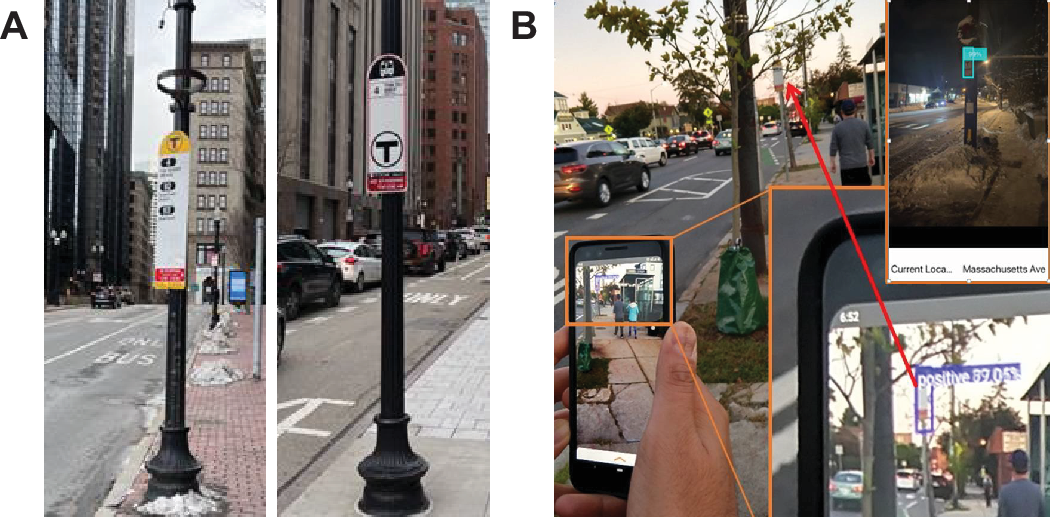
Running the All_Aboard app and the Google Maps app simultaneously to find bus stops. (A) Screenshot of the device at the start point. Both the All_Aboard app and the Google Maps app (inset) were launched and run simultaneously. (B) A user holds the phone upright with the rear camera facing straight ahead. (C) Screenshot of the device when the Google Maps app indicate arrival at the destination. The All_Aboard app indicates the physical bus stop sign is still some distance ahead. (CREDIT: TVST)
To assess the app's performance, the researchers conducted a study involving 24 visually impaired individuals who used both All_Aboard and Google Maps to navigate a predefined route with ten bus stops in both urban (Boston) and suburban (Newton, Mass.) settings.
The study measured the success rate of localization and the degree of localization error. Localization error, often referred to as gap distance, represents the distance between the intended destination and the point marked on the map. The success rate of localization indicates the probability of getting close enough to the bus stops.
This cutting-edge app, named "All_Aboard," outperforms Google Maps in helping BVI individuals navigate their way to bus stops with astonishing success rates. (CREDIT: All_Aboard Apple App Store Listing)
The outcomes of the study were nothing short of astounding. In both urban and suburban locations, All_Aboard boasted an impressive success rate of 93 percent, while Google Maps lagged behind at a mere 52 percent success rate. Moreover, the average gap distance with Google Maps stood at 6.62 meters, while All_Aboard dramatically reduced this gap to just 1.54 meters.
Dr. Gang Luo, affiliated with the Schepens Eye Research Institute of Mass Eye and Ear, expressed his insights into the study's findings. He noted that GPS accuracy is generally expected to be acceptable in suburban areas, but the subpar performance of Google Maps in Newton, Mass. was a surprising revelation. Previous research conducted by Dr. Luo and his team suggests that the problem might be rooted in the widespread inaccuracies of bus stop location data within Google Maps.
Dr. Luo elaborated, saying, "Our findings suggest that the All_Aboard app could help travelers with visual impairments in navigation by accurately detecting the bus stop, and therefore greatly reducing their chance of missing buses due to standing too far from the bus stops. This study indicates that computer vision-based object recognition capabilities can be used in a complementary way and provide added benefit to purely mapping-based, macro-navigation services in real-world settings."
The All_Aboard app is undoubtedly a beacon of hope for individuals with visual impairments, opening up new possibilities for independent and efficient navigation. With its remarkable success in the study, this technology could pave the way for a brighter and more accessible future for the visually impaired community.
For more environmental news stories check out our Green Impact section at The Brighter Side of News.
Note: Materials provided above by The Brighter Side of News. Content may be edited for style and length.
Like these kind of feel good stories? Get the Brighter Side of News' newsletter.