Madagascar’s tilted past: How two ancient rifts sculpted a living island
Madagascar’s landscape and rich biodiversity were shaped by two ancient rifting events that tilted the island and rewired its rivers.

 Edited By: Joseph Shavit
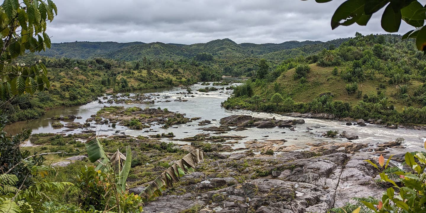
The Marimbona River in eastern Madagascar is a major waterway that channels vast amounts of runoff from the island’s humid eastern highlands down to the coastal plains. (CREDIT: Romano Clementucci / ETH Zurich)
Madagascar’s cliffs, rolling plateaus, and winding rivers weren’t shaped by a single violent event. Instead, the island’s breathtaking landscape took form through two massive tectonic rifts that happened tens of millions of years apart.
These shifts tilted the land, redirected rivers, and sculpted the island’s dramatic shape — steep cliffs dropping into the Indian Ocean on the east and gentle plains stretching toward the Mozambique Channel on the west. Together, these forces created not only a striking landscape but also one of the most biologically rich ecosystems on Earth.
Two Ancient Rifts, One Remarkable Island
Long before Madagascar stood alone in the ocean, it was part of the ancient supercontinent Gondwana. About 170 million years ago, the first big tectonic break separated it from Africa. The crust folded upward, forming a massive western escarpment, and rivers flowed east toward the Indian Ocean, cutting deep valleys into a rising plateau.
Roughly 80 million years later, another rift opened — this time between Madagascar, India, and the Seychelles. The island tilted again, but in the opposite direction. Land that once sloped east began to dip west, reversing river flow and shifting the island’s main watershed toward the east. The towering western escarpment eroded into scattered highlands, while a new, steep cliff line rose along the eastern coast.
“The water divide is the key to the geography of Madagascar,” said Romano Clementucci, a geologist at ETH Zurich and lead author of the new Science Advances study. “Each time the island tilted, the line separating rivers flowing east or west jumped across the island, changing how water and erosion shaped the land.”
Rivers That Redraw the Land
These tilts didn’t just bend river paths — they rebuilt the island’s surface. Old riverbeds were abandoned, new valleys were carved, and some rivers even reversed course. The result is striking: steep cliffs and fast rivers in the east, soft slopes and wide plains in the west.
Using high-resolution satellite imagery, erosion data, and computer models, Clementucci’s team mapped Madagascar’s slow transformation in remarkable detail. They used cosmogenic isotopes like beryllium-10 (^10Be), which build up in rocks exposed to cosmic rays, to measure how quickly erosion reshaped the island over millions of years.
Their results show erosion remains most intense along the eastern escarpment. In the south, cliffs retreat about 170 meters per million years. But in the north — a more tectonically active area — the pace quickens to nearly 3,800 meters per million years. By comparison, the central plateau erodes slowly, only about seven meters per million years, preserving remnants of Madagascar’s ancient surface.
Re-Creating an Island in Motion
To confirm their findings, researchers ran computer simulations of Madagascar’s geologic past. Each rifting event caused one side of the island to sink, creating a new escarpment that gradually eroded inward. During the second rift, the tilt reversed, and the entire landscape reshaped again.
The model successfully recreated Madagascar’s modern features — the sharp eastern escarpment, the gentle western slope, and the “knickpoints,” or sudden drops in river elevation, seen today. These knickpoints are relics of ancient changes in the island’s drainage system.
And the story isn’t over. Volcanic and tectonic forces continue to reshape Madagascar today, especially in regions like the Ankaratra volcanic field and the Alaotra–Ankay Graben. These active zones still alter river courses, sink parts of the plateau, and produce mild earthquakes — signs that the island’s crust is far from quiet.
A Landscape That Gave Rise to Life
Madagascar’s incredible biodiversity — from lemurs and chameleons to baobabs — has long been credited to isolation and climate. Clementucci’s study adds another key factor: geology.
The team found a strong link between erosion rates and plant diversity along the eastern escarpment. Where slopes are steeper and rivers shift more often, plant species multiply — from roughly 1,200 in the south to more than 2,000 in the north. Rainfall alone can’t explain the difference. Instead, the land’s constant reshaping seems to have fragmented habitats and pushed species to evolve separately.
In essence, Madagascar’s shifting terrain acted like a “speciation pump.” When rivers changed course or valleys deepened, populations became isolated and began to evolve on their own. That process helped produce the island’s astonishing biodiversity — where more than 90% of mammals and reptiles and over 80% of plants exist nowhere else on Earth.
“Our research shows that ancient tectonic forces rejuvenated Madagascar’s surface,” Clementucci said. “By tilting the island and shifting its main rivers and mountains, these forces created fragmented environments where species evolved in isolation — especially along the island’s striking eastern escarpment.”
Lessons From a “Quiet” Continent
Madagascar’s story challenges the assumption that so-called “passive” continental margins — like those in Brazil, South Africa, or Australia — are geologically stable. Even after rifting ends, slow but steady movements can keep reshaping landscapes and influencing ecosystems.
This understanding may also explain why other “ancient” islands host so much biodiversity. Even subtle geological shifts, spread over millions of years, can shape how species form, adapt, and survive.
Why It Matters
By linking geology and biodiversity, this study shows how deeply life is tied to a changing Earth. The living and non-living parts of our planet evolve together — one shaping the other over time.
For conservationists, the findings emphasize protecting entire landscapes, not just isolated habitats. The same tectonic and erosional forces that once created diversity could, if disrupted, permanently fracture ecosystems.
As Madagascar continues to move and wear away, it stands as living proof that the Earth is never truly still — it tilts, breathes, and builds life in the process.
Research findings are available online in the journal Science Advances.
Related Stories
- Massive fault line under the Himalayas is tearing India apart
- All living mammals evolved from this country - 50 million years earlier than previously thought
- Fierce crocodile relative Kostensuchus atrox found in Patagonia
Like these kind of feel good stories? Get The Brighter Side of News' newsletter.
Joshua Shavit
Writer and Editor
Joshua Shavit is a NorCal-based science and technology writer with a passion for exploring the breakthroughs shaping the future. As a co-founder of The Brighter Side of News, he focuses on positive and transformative advancements in technology, physics, engineering, robotics, and astronomy. Joshua's work highlights the innovators behind the ideas, bringing readers closer to the people driving progress.