Zealandia: Scientists discovered Earth’s missing 8th continent
Uncover Zealandia, Earth’s hidden eighth continent. Discover its geological evolution from Gondwana to its present submerged state.
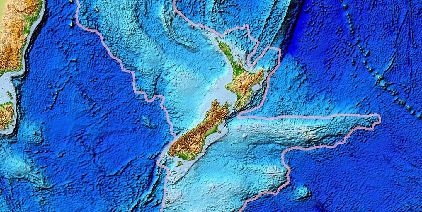
“By dating these rocks and studying the magnetic anomalies they presented,” the researchers said, “we were able to map the major geological units across North Zealandia.” (CREDIT: Tectonic)
Beneath the turquoise waters of the South Pacific hides a massive secret—Zealandia, a sunken landmass stretching nearly two million square miles. Though mostly underwater, this geological giant has sparked debate as a possible eighth continent. Just 5% of its surface peeks above sea level, making it one of Earth’s most elusive landforms.
The Ancient Land Under The Sea
Zealandia wasn’t always underwater. Its story begins over 100 million years ago when it was part of the vast southern supercontinent, Gondwana. That ancient land once held what would become Africa, South America, Antarctica, Australia, and the Indian subcontinent. As Gondwana slowly broke apart, Zealandia’s own journey began.
Roughly 85 million years ago, the southern section split from what is now West Antarctica. About 25 million years later, the northern section detached from Australia. These shifts pushed Zealandia away from its neighbors, setting the stage for its quiet descent beneath the ocean’s surface.
Unlike nearby continents, Zealandia didn’t stay afloat. During the Paleogene period, its crust thinned and cooled. That shift triggered its gradual sinking. Today, only New Zealand and New Caledonia remain above water, offering hints of the massive landmass that lies beneath. A tectonic boundary now divides Zealandia into northern and southern sections, tracing along the Pacific and Australian plates.
Zealandia's Hidden Secrets
Although the idea of an underwater continent first surfaced decades ago, it struggled to gain wide scientific support. But recent findings have changed that. With new data and sharper tools, researchers are reevaluating Zealandia’s geological identity—and taking it seriously.
One breakthrough came from a study published in Tectonics, led by geologist Nick Mortimer and a team from GNS Science. Their work offers strong evidence for Zealandia’s continental status, pushing this sunken world into the scientific spotlight.
Related Stories
The team conducted geological surveys across the northern stretches of Zealandia, employing advanced dredging techniques. They collected a range of rock samples from the Fairway Ridge to the Coral Sea, including sandstone, mudstone, limestone, and basaltic lava. These samples provided crucial insights into Zealandia's geological timeline.
“By dating these rocks and analyzing their magnetic anomalies, we mapped the major geological units of North Zealandia,” the team explained. This marked the completion of the first comprehensive offshore geological mapping of the Zealandia continent.
A Geological Time Capsule
The retrieved rocks tell a captivating story. Some sandstone samples date back approximately 95 million years to the Late Cretaceous period. Granite and volcanic pebbles from as far as 130 million years ago reveal Zealandia's Early Cretaceous past. Basalt samples, meanwhile, represent more recent history, originating from the Eocene epoch around 40 million years ago.
These findings challenge previous assumptions about Zealandia’s formation. Conventional theories suggested a strike-slip breakup, where tectonic plates slide past each other horizontally.
However, Mortimer’s team proposed a different scenario. They believe plate stretching created subduction-like fractures, leading to the formation of the Tasman Sea. Subsequent tectonic activity further thinned Zealandia’s crust, relegating it to an underwater existence.
Geological Significance Beyond the Surface
The implications of Zealandia’s geological evolution extend beyond academic interest. Understanding its unique features, such as crustal thinning up to 65%, sheds light on broader tectonic processes. These insights also highlight Zealandia’s role in shaping the Pacific region's dynamic geology.
According to a GNS Science researcher, “Zealandia’s underwater status in no way diminishes its geological significance.” Its vast expanse and diverse rock formations make it a valuable natural laboratory for studying Earth's tectonic history.
Future Exploration
Zealandia remains an active area of research. Its submerged status poses challenges, but advances in technology, such as deep-sea dredging and seismic imaging, continue to unlock its secrets. Ongoing studies aim to refine our understanding of this hidden continent, offering a more comprehensive picture of Earth's geological past.
As scientists continue to explore Zealandia, they not only reveal the continent's mysteries but also enhance our understanding of the planet’s ever-evolving story.
Note: Materials provided above by The Brighter Side of News. Content may be edited for style and length.
Like these kind of feel good stories? Get The Brighter Side of News' newsletter.