Rock glaciers worldwide may hold about 48 gigatons of water
A Utah rock glacier hides enough ice to fill 600 Olympic pools, revealing a vast mountain water reserve beneath loose rubble
 University of Utah Writer: Brian Maffly

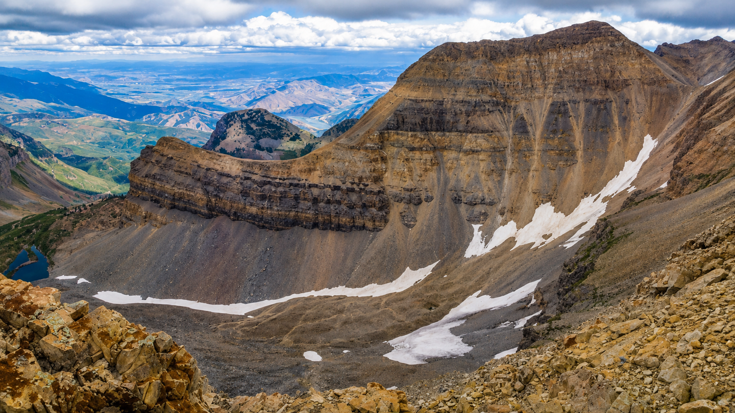
Scientists mapped 1.55 million cubic meters of hidden ice beneath Utah’s Timpanogos Rock Glacier using gravity measurements. (CREDIT: Logan Tuura)
- A rock-covered glacier beneath Mount Timpanogos contains about 1.55 million cubic meters of ice, enough frozen water to fill roughly 600 Olympic swimming pools.
- University of Utah geologists used tiny changes in gravity to build a three-dimensional image of ice buried beneath the rubble, finding an ice-rich core that is about 83% ice.
- The findings suggest rock glaciers are important hidden water stores, with researchers estimating that known rock glaciers worldwide may hold about 48 gigatons of water.
From a distance, the jumble of broken rock beneath Mount Timpanogos looks more like a giant rubble pile than a glacier.
Beneath that rocky surface, however, lies an enormous reservoir of ice.
University of Utah geologists have now mapped that hidden ice in three dimensions, finding that Timpanogos Rock Glacier contains about 1.55 million cubic meters of ice. That is enough frozen water to fill roughly 600 Olympic swimming pools and is comparable in volume to the largest pyramid at Giza.
Two studies examining the landform also offer a clearer explanation for how such rock glaciers form and why they may become increasingly important as mountain ice changes.
The gravity-imaging work appears in the Journal of Geophysical Research: Earth Surface. Related research on how snow and falling rock add mass to Timpanogos Rock Glacier was published in Geophysical Research Letters.
A glacier hidden beneath rubble
Rock glaciers differ sharply in appearance from conventional glaciers. Instead of exposed ice, their surfaces are covered by loose rocks and debris that can conceal thick masses of frozen material.
They occur throughout Utah’s Wasatch and Uinta ranges and even in the La Sal Mountains near Moab. Researchers have documented 836 rock glaciers across Utah using satellite imagery.
“There’s a lot of ice that’s hidden in Utah’s mountains,” University of Utah glaciology professor Leif Anderson said. “When we are high in the mountains and walking across loose rocks or rubble, you don’t realize there could be 120 feet of ice buried beneath your feet.”
Timpanogos Rock Glacier sits in a north-facing basin beneath Mount Timpanogos, about seven kilometers from the developed eastern side of Utah Valley.
It stretches roughly 800 meters from end to end and measures between 100 and 200 meters wide.
Despite its rocky appearance, the landform remains active. Measurements show its surface moving downhill at roughly 8 to 20 centimeters per year.
Gravity reveals what rocks conceal
Seeing beneath several meters of loose debris is difficult.
Ground-penetrating radar commonly maps ordinary glacier beds, but rocks inside and above rock glaciers can scatter radar waves and reduce image quality. Other methods usually provide measurements along individual lines or at selected points rather than across an entire landform.
Bronson Cvijanovich, a former University of Utah geology and geophysics graduate student, led six field trips to Timpanogos Rock Glacier in 2024.
He carried a sensitive gravimeter across the rocky surface and recorded measurements at 232 locations, usually spaced about 25 meters apart.
The technique relies on a basic physical difference between rock and ice: rock is much denser.
“There is a large contrast in mass density between the rock that makes up Mount Timpanogos and the much lower density ice that is in rock glacier adjacent to it,” geophysics professor Michael Thorne said.
Gravity weakens slightly above areas containing more buried ice.
“When we measure the gravitational acceleration over the rock glacier, we see a larger decrease in that gravitational acceleration as we make measurements over areas with thicker ice,” Thorne said.
Building a 3D picture of buried ice
The raw measurements required extensive corrections.
The team accounted for changes caused by elevation, latitude, surrounding terrain and the positions of the Sun and Moon. Researchers then developed a Bayesian statistical method to turn the gravity measurements into a three-dimensional model.
“We spent months of computation time doing the imaging with our new techniques,” Thorne said.
The preferred two-layer model shows an average rock glacier thickness of about 18.8 meters. Some areas contain several tens of meters of ice-rich material.
The researchers calculated an ice volume of about 1.55 million cubic meters.
Across the entire modeled landform, ice represents roughly 72% of the volume. Within the ice-rich core itself, the mixture is about 83% ice and 17% rock.
“Timpanogos Rock Glacier is surprisingly ice rich. It is 83% ice and 17% loose rock,” Cvijanovich said.
How a rock glacier grows
The companion research addresses where that ice came from.
Rock glaciers form beneath steep mountain walls that continually shed debris. On Timpanogos, rocks falling from the surrounding slopes can bury lingering snow before it melts.
“In the Wasatch, the mountains themselves are eroding and burying the snow, and that’s why the rock glaciers exist,” Anderson said.
A mathematical model developed for Timpanogos shows that snowfall, avalanches, melting and rockfall can combine to preserve buried snow over long periods.
The findings indicate that Utah’s rock glaciers are not simply leftovers from the peak of the last Ice Age, about 21,000 to 18,000 years ago. Timpanogos Rock Glacier appears to have accumulated much later as repeated deposits of debris protected snow and ice.
The researchers estimated that, under modeled modern rates of ice addition and with negligible melting beneath the debris, building its current ice reservoir would require at least about 1,335 years. That represents a minimum estimate rather than a firm age.
Hidden water across the mountains
Timpanogos could also help improve estimates for much larger regions.
Scientists can map a rock glacier’s surface area from satellites, but estimating how much ice lies underneath has remained far more uncertain.
The team compared Timpanogos with 10 other rock glaciers that had geophysical measurements and developed a relationship between surface area and ice volume.
Using that relationship, the researchers estimate Utah’s rock glaciers contain water equivalent to about 0.99 gigatons. Known intact rock glaciers worldwide could contain about 48 gigatons.
Those estimates remain uncertain because relatively few rock glaciers have been mapped internally in three dimensions.
The importance extends beyond water storage. Rock glaciers can provide cold habitats for alpine plants and animals, while warming can increase their movement and contribute to instability.
The new gravity technique offers a way to investigate those hidden interiors directly.
For anyone walking across the broken rocks beneath Mount Timpanogos, the landscape may still look dry and solid. The measurements tell a very different story underneath.
Dig deeper into rock glaciers and hidden water stores
These resources explore the distribution, movement, ecology and climate sensitivity of rock glaciers, helping place Utah’s buried mountain ice within the broader science of changing alpine environments.
Researchers produced an updated inventory of rock glaciers across the western United States, identifying 2,257 features and examining how their distribution relates to temperature, precipitation and elevation. (Arctic, Antarctic, and Alpine Research, 2025)
This modeling study found that rock glacier habitat could shrink substantially as climate conditions change, with a high-end warming scenario producing a projected 99% reduction after the landscape reaches climatic equilibrium. (Journal of Glaciology, 2024)
Work in Utah’s Uinta Mountains found that a rock glacier has existed for roughly 10,000 years and is currently moving faster than its long-term average, showing how these landforms evolve over millennial timescales. (Journal of Geophysical Research: Earth Surface, 2024)
Researchers studying Alpine springs found that cold water emerging from rock glaciers can support cold-adapted invertebrates, suggesting these “icy seeps” may serve as refuges as conventional glacier habitats disappear. (Biodiversity and Conservation, 2024)
This broad review examines ice storage, runoff, water chemistry and the long-term hydrological importance of rock glaciers, including their potential role as persistent water stores in warming mountain regions. (Earth-Science Reviews, 2019)
Research findings are available online in the journals JGR Earth Surface and Geophysical Research Letters.
The original story "Rock glaciers worldwide may hold about 48 gigatons of water" is published in The Brighter Side of News.
Related Stories
- AI maps ice levels beneath the world’s glaciers - could raise global sea levels by over a foot
- Quiet cracking is destabilizing Antarctica’s Doomsday Glacier leading to irreversible collapse
- Chile’s megadrought is dealing a severe and long-lasting blow to their glacier ecosystems
Like these kind of feel good stories? Get The Brighter Side of News' newsletter.
Joseph Shavit
Writer, Editor-At-Large and Publisher
Joseph Shavit, based in Los Angeles, is a seasoned science journalist, editor and co-founder of The Brighter Side of News, where he transforms complex discoveries into clear, engaging stories for general readers. With vast experience at major media companies like The Los Angeles Times, Times Mirror and Tribune Publishing, he writes with both authority and curiosity. His writing focuses on space science, planetary science, quantum mechanics, geology. Known for linking breakthroughs to real-world markets, he highlights how research transitions into products and industries that shape daily life.