A massive rift is splitting Africa apart forming Earth’s sixth ocean
East Africa’s rift is widening by millimeters a year, revealing the early tectonic steps that can eventually create a new ocean.

 Edited By: Joshua Shavit

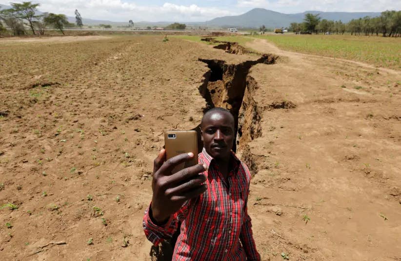
In the vast deserts of Ethiopia, a remarkable phenomenon has been quietly unfolding since 2005—an extraordinary 35-mile-long crack known as the East African Rift. (CREDIT: Reuters)
The desert floor in Ethiopia looks fixed and ancient, but it is moving. Across the Afar region and down the East African Rift, the African continent is being pulled apart by forces deep below the surface, setting up a process that could, over millions of years, create a new ocean basin.
That idea can sound like science fiction because the motion is so slow. But the change is measurable, and in geological terms it is already underway.
A study in Earth and Planetary Science Letters examined how the Nubian and Somalian plates are shifting relative to one another, using GPS data to refine where the boundary lies and how fast different parts of the region are opening. The picture that emerges is not of one dramatic break, but of a continent stretching, fracturing, and reorganizing itself in ways that are already visible from the ground.
At the center of that story is the East African Rift, a vast system of extensional structures that runs from about 11 degrees north to roughly 20 degrees south. At its northern end, it meets the Red Sea and the Gulf of Aden at the Afar Triple Junction, the only emerged ridge-ridge-ridge triple junction on Earth described in the paper.
Measuring motion that takes millions of years
The research focused on a basic but difficult problem in tectonics: defining how stable parts of plates move. Older kinematic models relied mostly on geological and geophysical evidence averaged over millions of years. More recent work can track present-day motion through space geodesy, especially GPS, which allows scientists to measure how fixed points on Earth’s surface shift in a common reference frame.
That is especially important in Africa, where the continent had long been treated in many global plate models as a single tectonic unit, even though geological, geophysical, and geodetic evidence pointed to differential motion between Nubia and Somalia, particularly near the Ethiopian Rift.
To improve the estimates, the authors used data from the GPS for African Studies network. After screening stations for reliability, they based their plate calculations on 10 stations on Nubia and four on Somalia. They then independently calculated angular velocities for the two plates in the ITRF2000 reference frame.
The fit between observed and predicted motions was tight. For the stations used in the model, the weighted root mean square of the residuals was 0.7 millimeters per year for Nubia and 1.0 millimeter per year for Somalia. The largest horizontal residuals were 1.7 millimeters per year and 1.2 millimeters per year, respectively.
Those tiny numbers matter because they show the plate model closely matches the data. In other words, the split is not just a broad idea drawn from landscape clues. It shows up in direct measurements.
What the rift is doing now
The study’s relative angular velocity solution for Somalia with respect to Nubia predicts opening along the entire Nubia-Somalia plate boundary. The maximum opening rate reaches 6.9 millimeters per year in the Afar region, then drops to 1.9 millimeters per year closer to the Nubia-Somalia-Antarctica triple junction.
That helps explain why the Ethiopian Rift has become such a focal point for understanding how continents break apart. In the Afar region, the model agrees well with geological and geophysical evidence of extension. The paper also says the predicted motion there matches independent GPS measurements in Afar and combined laser-ranging and GPS measurements in the Addis Ababa area.
The boundary itself is not simple. The East African Rift splits into western and eastern branches, and the study suggests the area between them may not behave as a single clean dividing line. One GPS site, MBAR, sits between the branches and moves in a way that is intermediate between stable Nubia and stable Somalia.
That matters because it points to deformation between the branches rather than a simple fault-like split. The authors say the data are not enough to determine whether that region is a stable tectonic block, sometimes called the Victoria block, or an area of continuous deformation.
Farther south, the picture grows murkier. Different published models predict very different behavior near the southern end of the boundary, including opening, right-lateral motion, and even compression. The paper argues that more data are needed there, even as its own solution favors opening and places the Somalia-Nubia boundary along the contour of the South African plateau in that region.
A continent in slow transition
What makes this rifting so compelling is not just that it can be measured, but that it represents an early stage of ocean formation. The process mirrors, in broad tectonic terms, the way older ocean basins opened when continents split apart.
Ken Macdonald, a marine geophysicist and professor emeritus at the University of California, described the long-term outcome in vivid terms: “The Gulf of Aden and the Red Sea will flood over the Afar region and into the East African Rift Valley, giving rise to a new ocean.” He added, “Consequently, this part of East Africa will evolve into its own distinct continent.”
That is a striking image, but the study itself remains focused on kinematics, not spectacle. Its main contribution is to sharpen estimates of how Nubia and Somalia move today and to show that the relative motions are broadly consistent with the known tectonic setting of the plate boundary.
The authors are careful about what remains unresolved. They conclude that the Nubian plate’s angular velocity is already defined with relatively high accuracy, while the Somalian plate still needs more confirmation, even though the new estimate is probably the most accurate presented so far because it uses a better distributed and larger space-geodetic data set than earlier work.
They also note that in South Africa, the GPS time series suggest HRAO belongs to stable Nubia, while RBAY is part of stable Somalia. In the Lake Victoria region, meanwhile, MBAR appears to record deformation between the rift branches rather than clean attachment to one rigid plate.
The world's five major oceans
The world’s oceans play a critical role in shaping Earth’s climate, biodiversity, and geological features. Covering about 71% of the Earth’s surface, they are divided into five major oceans: the Pacific, Atlantic, Indian, Southern, and Arctic. Here’s an overview of each ocean along with insights into when they formed in Earth’s planetary evolution.
1. Pacific Ocean
- Size: Largest and deepest ocean, covering more than 63 million square miles and with a maximum depth of about 36,000 feet in the Mariana Trench.
- Formation: The Pacific Ocean began forming about 750 million years ago when the supercontinent Rodinia started breaking apart. It grew as the supercontinents Pangaea and later Gondwana split.
- Fact: The Pacific contains more than 50% of the Earth’s free water and experiences the most tectonic activity, leading to frequent earthquakes and volcanic eruptions.
2. Atlantic Ocean
- Size: Second largest ocean, spanning over 41 million square miles.
- Formation: The Atlantic formed about 200 million years ago during the breakup of Pangaea. The rifting caused the North Atlantic Ocean to open first, followed by the South Atlantic.
- Fact: The Mid-Atlantic Ridge, an underwater mountain range, is a key feature that continues to expand the ocean today as tectonic plates move apart.
3. Indian Ocean
- Size: The third largest ocean, covering about 27 million square miles.
- Formation: The Indian Ocean began forming during the breakup of Gondwana about 180 million years ago as the African and Antarctic plates drifted apart.
- Fact: It’s the warmest ocean, which has a significant influence on weather patterns such as monsoons and the El Niño-Southern Oscillation (ENSO).
4. Southern Ocean
- Size: Fourth largest, encircling Antarctica and spanning around 7 million square miles.
- Formation: Although the waters existed for hundreds of millions of years, the Southern Ocean as a distinct body was designated only in the early 2000s. Geologically, it formed as the Antarctic Plate separated from South America and Australia, allowing a circumpolar current to develop.
- Fact: The Southern Ocean has a unique circulation pattern known as the Antarctic Circumpolar Current, which plays a key role in global heat distribution.
5. Arctic Ocean
- Size: The smallest and shallowest ocean, covering about 5.4 million square miles.
- Formation: The Arctic Ocean has been shaped by tectonic movements over the past 200 million years, but it reached its modern configuration relatively recently during the Pleistocene epoch, about 2.6 million years ago.
- Fact: It has a distinct ecosystem due to its seasonal ice cover, and the ongoing loss of sea ice due to climate change is dramatically affecting the region.
Practical implications of the research
This work does not say East Africa will become a new ocean tomorrow, or even in the near future. The timescale is measured in millions of years. But it does show that the breakup process is real, measurable, and more structurally complex than a simple line on a map.
For Earth scientists, that matters because better plate-motion models improve how researchers study continental deformation, seismicity, and the mechanics of rifting.
For the region itself, the study underscores that the landscape is part of an active tectonic system whose long-term evolution could eventually redraw coastlines, reorganize ecosystems, and change how people think about the shape of Africa itself.
Research findings are available online in the journal Earth and Planetary Science Letters.
The original story "A massive rift is splitting Africa apart forming Earth's sixth ocean" is published in The Brighter Side of News.
Related Stories
- Geophysicists solve the mystery of a 75-year-old ‘gravity hole’ in the Indian Ocean
- East Africa’s Turkana Rift may be closer to splitting than scientists thought
- Tethys Seaway: The lost ocean that forever changed life on Earth
Like these kind of feel good stories? Get The Brighter Side of News' newsletter.
Joseph Shavit
Writer, Editor-At-Large and Publisher
Joseph Shavit, based in Los Angeles, is a seasoned science journalist, editor and co-founder of The Brighter Side of News, where he transforms complex discoveries into clear, engaging stories for general readers. With vast experience at major media companies like The Los Angeles Times, Times Mirror and Tribune Publishing, he writes with both authority and curiosity. His writing focuses on space science, planetary science, quantum mechanics, geology. Known for linking breakthroughs to real-world markets, he highlights how research transitions into products and industries that shape daily life.