
A giant Pompeii-scale eruption buried an ancient Andes landscape and preserved it for 22 million years
An enormous Chilean eruption buried an ancient landscape whose shape now reveals how quickly the Andes were rising before disaster struck.
 UCL Writer: Mark Greaves

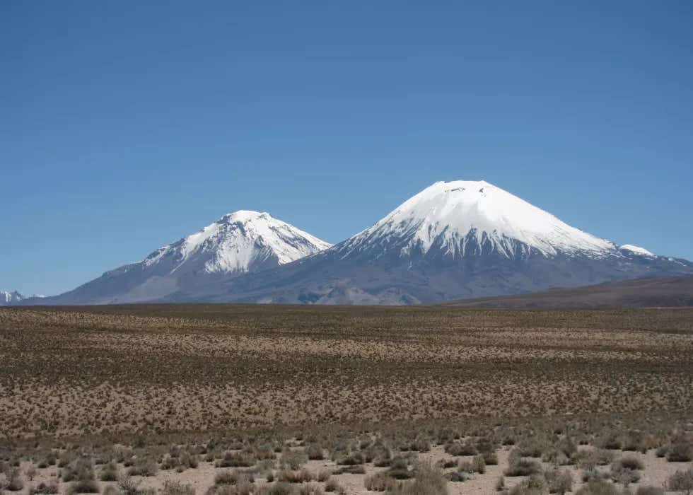
A 21.9-million-year-old volcanic blanket preserved clues showing part of the Andes may have risen slowly for millions of years. (CREDIT: Frances J. Cooper)
- A 21.9-million-year-old volcanic deposit in northern Chile has preserved the shape of an ancient Andean landscape, allowing researchers to estimate how quickly the mountains were rising before the eruption.
- Computer models show that only relatively gentle terrain could have been completely buried beneath the Cardones ignimbrite, placing the average pre-eruption rock uplift rate below about 0.26 kilometers per million years.
- The result supports a slow, sustained history of Andean growth in this region and introduces a new method for reconstructing landscapes that disappeared beneath enormous volcanic deposits millions of years ago.
A volcanic eruption of extraordinary size buried an entire Andean landscape nearly 22 million years ago. Instead of erasing its history, that catastrophe may have preserved clues to how quickly one of Earth's greatest mountain ranges was growing.
Researchers used the enormous Cardones ignimbrite in northern Chile to reconstruct the terrain that existed before the eruption. Their analysis suggests the buried landscape consisted of relatively gentle mountain foothills rather than the steep relief expected from rapidly rising mountains.
The study was published in Science Advances by researchers including Byron Adams and Frances Cooper of UCL Earth Sciences. Their modeling places the average pre-eruption rock uplift rate below about 0.26 kilometers per million years.
That corresponds to roughly 2.6 centimeters every century, supporting the idea that this part of the Andes rose slowly over millions of years rather than suddenly surging upward late in its history.
A volcanic blanket froze an ancient landscape
The evidence comes from the Cardones ignimbrite, an enormous volcanic deposit associated with the Lauca Caldera in the Central Andes. It was emplaced about 21.9 million years ago during the early Miocene.
Ignimbrites form when fast-moving pyroclastic density currents sweep across the ground during explosive eruptions. These mixtures of hot ash, pumice, rock fragments and gas can travel enormous distances before settling into thick deposits.
The Cardones eruption produced more than 1,260 cubic kilometers of material. In places, the deposit exceeded a kilometer in thickness and spread across an area several times larger than a major metropolitan region.
“This landscape was buried by a giant volcanic eruption, a little like Pompeii, but on a vastly larger scale,” Adams said. Instead of preserving streets and buildings, the volcanic material covered valleys, ridges and river networks.
Large deposits of this type often produce broad surfaces dipping only a few degrees away from their volcanic source. The Cardones surface originally sloped about 1.5 degrees, with an uncertainty of roughly 0.3 degrees.
That gentle volcanic blanket became the key to reconstructing what lay underneath.
The volcanic surface placed a limit on the buried mountains
The researchers used a straightforward geometric insight. For the eruption to completely bury an ancient landscape, the overall slope of that landscape could not have been substantially steeper than the volcanic surface covering it.
Otherwise, major ridges and peaks should have projected through the deposit.
“We cannot dig down to see the buried landscape, but we can use the shape of the volcanic blanket and what we know about how rivers shape mountains to infer what is hidden beneath it,” Adams said.
The team therefore modeled hundreds of possible landscapes shaped by different combinations of tectonic uplift and river erosion. Their two-dimensional experiments used a landscape-evolution framework in which rivers cut into rising terrain over long periods.
They generated 560 synthetic landscapes while varying rock uplift from 0.1 to 2 kilometers per million years and changing how easily rivers could erode the underlying rock.
Faster uplift generally created steeper river channels and greater relief. Slower uplift gave rivers more opportunity to cut down the terrain, producing gentler landscapes capable of fitting beneath the Cardones deposit.
Rivers revealed how quickly the Andes could have risen
The researchers then compared the synthetic landscapes with the geometric limit established by the roughly 1.5-degree ignimbrite surface.
When they restricted erosion efficiency to values considered plausible for the region's bedrock and climate, the possible uplift rates narrowed substantially. Landscapes compatible with complete burial required average rock uplift below approximately 0.26 kilometers per million years.
The method does not reconstruct every ancient hill and valley. Instead, it places an upper limit on the broad relief that could have existed before volcanic burial.
That distinction is important because mountain landscapes are constantly changing. Rivers cut downward while tectonic forces push rock upward, and climate and rock type affect how rapidly that erosion proceeds.
The models also indicate that developing the subdued terrain would have required millions of years. Under one representative set of conditions, reaching 95% of the modeled steady-state relief required at least about 14 million years.
“In this case, we estimate it would have taken millions of years to produce the subdued landscape we infer prior to the eruption,” Adams said.
The Andes may have grown slowly instead of suddenly
The history of Andean uplift remains debated. One broad possibility is that the range developed gradually over tens of millions of years. Another proposes relatively limited early elevation followed by episodes of rapid uplift during the last several million years.
The buried Cardones landscape provides an independent way to examine part of that history.
“There is debate over whether the Andes grew slowly and steadily over 40 or 50 million years or whether they rose extremely slowly and then popped up more recently, in the last six to 10 million years,” Adams said. “Our findings, which cover a large part of the middle of that history, support the slow but steady hypothesis.”
The calculated rate also agrees broadly with earlier geological evidence based on minerals that record their cooling history as rocks move upward through Earth's crust. Those techniques are powerful, but they constrain particular intervals and require models to convert temperature histories into uplift or exhumation rates.
The volcanic-landscape approach provides a different measurement. Instead of relying on a chemical clock inside rocks, it asks what kind of topography could physically have existed beneath a dated volcanic deposit.
Ancient eruptions could become tools for reading mountain history
The technique may extend far beyond northern Chile. Large, low-angle ignimbrites occur in volcanic regions around the world, and some retain surfaces that can serve as geological reference planes.
That could turn catastrophic eruptions into unexpected archives of vanished terrain. Where the volcanic deposit's original geometry is understood, researchers could model the landscapes it covered and place constraints on earlier tectonic conditions.
“What’s particularly exciting about this study is that it gives us a new way of piecing together that history,” Cooper said. “The same approach could be applied to volcanic deposits elsewhere in the world, helping us reconstruct landscapes buried for millions of years.”
The technique also comes with limits. Erosion efficiency depends on climate and rock type, while ancient landscapes may not have been in perfect equilibrium when they disappeared. The researchers therefore frame the result as a bound on long-term average uplift rather than an exact record of every tectonic change.
Still, the Cardones deposit demonstrates how a landscape apparently destroyed by volcanism can preserve information about what came before it.
Pompeii froze a moment in human history. In the Andes, a vastly larger eruption appears to have frozen a chapter of mountain-building history beneath more than a thousand cubic kilometers of volcanic rock.
Dig deeper into Andean uplift, ignimbrites and landscape evolution
These resources examine the Cardones deposit, Central Andean mountain building and the river-erosion models that allow ancient landscapes to record tectonic change.
Using ignimbrites to quantify structural relief growth and understand deformation processes: Implications for the development of the Western Andean Slope, northernmost Chile: Reconstructs the original geometry of the 21.9-million-year-old Cardones ignimbrite and uses it to investigate deformation and relief development along the western Andes. (Lithosphere, 2017)
Causes of fragmented crystals in ignimbrites: a case study of the Cardones ignimbrite, Northern Chile: Examines the more than 1,260-cubic-kilometer Cardones deposit and the fragmentation, welding and compaction processes that shaped this exceptionally thick ignimbrite. (Bulletin of Volcanology, 2018)
Tectonic Evolution of the Central Andean Plateau and Implications for the Growth of Plateaus: Reviews competing models for the development of the Central Andes, including gradual and more episodic uplift histories across different portions of the plateau. (Annual Review of Earth and Planetary Sciences, 2017)
The stream power river incision model: evidence, theory and beyond: Evaluates the stream-power framework widely used to connect river incision, channel slope, erosion and tectonic forcing in evolving mountain landscapes. (Earth Surface Processes and Landforms, 2014)
Dynamics of the stream-power river incision model: Implications for height limits of mountain ranges, landscape response timescales, and research needs: Establishes key relationships among river incision, uplift, mountain relief and the time landscapes require to respond to tectonic change. (Journal of Geophysical Research: Solid Earth, 1999)
Research findings are available online in the journal Science Advances.
The original story "A giant Pompeii-scale eruption buried an ancient Andes landscape and preserved it for 22 million years" is published in The Brighter Side of News.
Related Stories
- Almost 500 years after its last eruption, Italy’s supervolcano is growing restless
- Ancient English supervolcano blasted ash across northern Europe 454 million years ago
- Ancient Toba eruption reveals a supervolcano can stay dangerous for thousands of years
Like these kind of feel good stories? Get The Brighter Side of News' newsletter.
Joshua Shavit
Writer and Editor
Joshua Shavit is a NorCal-based science and technology writer with a passion for exploring the breakthroughs shaping the future. As a co-founder of The Brighter Side of News, he focuses on positive and transformative advancements in technology, physics, engineering, robotics, and astronomy. Having published articles on AOL.com, MSN, Yahoo News, and Ground News, Joshua's work highlights the innovators behind the ideas, bringing readers closer to the people driving progress.