For the first time, scientists record underwater landslides in real-time
Sonar captured a Canadian delta peeling away underwater, showing how slowly unfolding landslides send sediment into deeper water.
 Durham University Writer: Araf Din

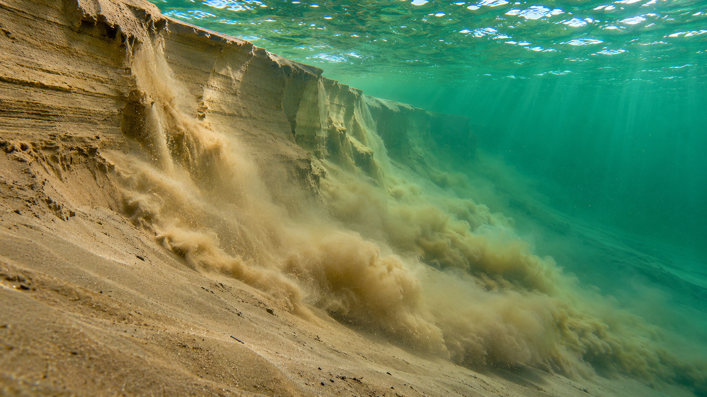
Sand peels away from a steep underwater slope, feeding a sediment-filled current that hugs the seabed in this artist’s reconstruction. Researchers used sonar to capture this gradual process, called breaching, at British Columbia’s Homathko Delta. (CREDIT: The Brighter Side of News)
- Sonar captured three naturally occurring underwater landslides as they unfolded at British Columbia’s Homathko Delta, providing direct evidence of a slow failure process called breaching.
- Repeat seabed maps revealed about 30 slides in 11 days. Together, they removed roughly 61,000 cubic meters of sediment from the delta.
- The slides fed sediment currents that reached at least two kilometers downslope, showing how repeated small failures can affect areas well beyond the original slide.
The edge of a sandy delta in British Columbia gave way a little at a time for more than an hour. From the surface, there was no view of the collapse. Beneath the water, sonar was taking an image about once a second as sand fell away from a steep face and a cloud of sediment formed downslope.
Researchers including Matthieu Cartigny of Durham University and first author Rob Englert reported the observations in Science. The work provides the first direct observations of breaching in naturally occurring landslides that took place entirely underwater. Breaching happens when a steep face slowly retreats as sediment comes away from it.
The discovery adds a time sequence to what seafloor mapping can show. A map made after a slide can reveal what disappeared and where a scar formed. Images taken during the slide can show whether the slope failed in one abrupt movement or kept shedding material over many minutes. Those different behaviors matter when assessing what may happen to nearby offshore infrastructure.
Catching the seabed as it moves
The Homathko River empties into Bute Inlet, a fjord on Canada’s Pacific coast. Sand settles near the river mouth, building a delta with a steep submerged front. Below it, a long channel carries sediment into the inlet. The delta offered the researchers a place to watch how material moves from the river mouth toward deeper water.
Over 18 days in 2022, the team used two stationary sonars to watch part of the delta front. One looked across the slope and the other looked down, giving researchers different views of the changing seabed. They also made daily maps and moored a water-clarity sensor farther down the channel. The combination let them track changes at the source and detect sediment moving beyond the monitored slope.
The instruments served different purposes. Repeat surveys measured the scars that remained after a failure, much as ocean surveys can locate features important for routing cables. The stationary sonar showed the moving edge of individual failures. The clarity sensor picked up changes in the water itself, where suspended sediment can carry material far beyond the coastal seabed.
Sonar makes an image from echoes. A strong return can come from a steep face or material moving through the water, so a bright patch alone tells only part of the story. During the September 7 event, the two sonar views helped show how the appearance of new scarps coincided with a moving cloud near the bottom. As that cloud thickened, the downward-looking instrument temporarily lost sight of the seabed.
How a slow landslide moves uphill
The team captured three events in enough detail to identify breaching. In those events, the slide faces retreated upslope at rates between two and 27 millimeters per second. The observed events lasted 38 to 100 minutes. Sand moved downhill throughout, while its point of departure moved uphill as material peeled away from the steep face.
Breaching can occur when tightly packed sand needs to expand before it can move. As the grains pull apart, the pressure of water in the spaces between them drops temporarily. Water then seeps in, allowing more sand to come away. That sequence can keep the face steep while it retreats. The team inferred the mechanism from the observed movement and duration, since it did not measure water pressure between the grains during each failure.
The retreat sometimes sped up or paused, and occasional abrupt collapses punctuated the slower motion. Those changes suggest that models of gradual failure may need to account for short bursts of faster movement. A fjord landslide can therefore unfold very differently depending on its setting and how the material gives way. The comparison matters for seabed cables below a sandy delta, where repeated sediment release can prolong exposure to a current.
A survey after the event could miss the difference between a slope that gave way quickly and one that retreated for more than an hour. Both can leave similar scars in sandy sediment. In this case, the long retreat and the measured speeds gave the researchers a way to distinguish gradual breaching from a much faster failure caused by liquefaction.
Small slides add up
Comparing the daily maps revealed about 30 failures over 11 days. The team estimated that they collectively removed about 61,000 cubic meters of material. That was roughly one-fifth of the sediment the river delivered along its bed during the study period. The estimate describes erosion from the delta front. The study did not track the final resting place of every grain.
The slides fed flows called turbidity currents. Suspended sand and finer sediment make the moving water denser than the water around it, causing it to run downhill along the seabed. The instruments detected sediment-laden water at least two kilometers down the channel, and the water there stayed cloudy for 12 to 14 hours.
That reach matters because sediment can carry organic carbon and coastal pollutants. A slide that begins near a river mouth can move those materials into deeper parts of a fjord. The volume measured at Homathko gives researchers a way to estimate how much sediment becomes available for such transport, while studies of deep-water habitats illustrate the range of environments farther from shore.
The researchers could directly identify breaching in only the three slides captured in detail. Elsewhere on the delta, similar slopes and grain sizes, comparable timing and changes in the channel floor pointed to the same process. The broader total therefore measures the scale of sediment removal, while the instrument records establish how the best-observed failures developed.
Practical implications
Engineers assessing routes for cables and pipelines need to consider the channel below a slide as well as the slope itself. A small failure near the top can supply sediment to a current that reaches equipment much farther away. Repeated monitoring can reveal where those channels are active and how long flows can persist, complementing surveys used to plan cable routes.
The researchers observed the failures during a period of high river flow and falling tides. Both are candidates for further study, since the observations show when failures occurred without establishing what started them. Monitoring during other seasons and at other deltas could help identify which conditions consistently precede breaching and whether the patterns hold beyond this site.
The most immediate change is in what researchers can measure. With an image each second, a failure that leaves an ordinary-looking scar becomes a record of slow retreat, brief collapses and sediment release. Those details can help explain how repeated slope failures reshape a delta and sustain currents long after the slide begins.
Dig deeper into underwater landslides and sediment flows
These studies examine how sediment currents move, reshape the seabed and carry carbon into deeper water.
The Global Turbidity Current Pump and Its Implications for Organic Carbon Cycling: Reviews how underwater currents move land-derived organic carbon and where it can become buried. (Annual Review of Marine Science, 2024)
Time-Lapse Seafloor Surveys Reveal How Turbidity Currents and Internal Tides in Monterey Canyon Interact With the Seabed at Centimeter-Scale: Uses repeat surveys to measure changes in the shape of the canyon floor. (Journal of Geophysical Research: Earth Surface, 2023)
Longest sediment flows yet measured show how major rivers connect efficiently to deep sea: Tracks flows from the Congo River mouth, including one that traveled more than 1,130 kilometers. (Nature Communications, 2022)
Turbidity currents can dictate organic carbon fluxes across river-fed fjords: Traces the movement and burial of organic carbon carried by sediment flows in Bute Inlet. (Journal of Geophysical Research: Biogeosciences, 2022)
First wide-angle view of channelized turbidity currents links migrating cyclic steps to flow characteristics: Uses acoustic imagery to examine how sediment flows alter features on a submarine channel floor. (Nature Communications, 2016)
Research findings are available online in the journal Science.
The original story "For the first time, scientists record underwater landslides in real-time" is published in The Brighter Side of News.
Related Stories
- Evidence of an Ice Age forest emerges from the North Sea floor
- What caused the Earth to shake every 90 seconds for 9 straight days in 2023? Mystery solved
- UW researchers create the first building-level map of landslide risk across the United States
Like these kind of feel good stories? Get The Brighter Side of News' newsletter.
Joshua Shavit
Writer and Editor
Joshua Shavit is a NorCal-based science and technology writer with a passion for exploring the breakthroughs shaping the future. As a co-founder of The Brighter Side of News, he focuses on positive and transformative advancements in technology, physics, engineering, robotics, and astronomy. Having published articles on AOL.com, MSN, Yahoo News, and Ground News, Joshua's work highlights the innovators behind the ideas, bringing readers closer to the people driving progress.